Istituto di Scienza e Tecnologia dell'Inquinamento Luminoso
Light Pollution Science and Technology Institute
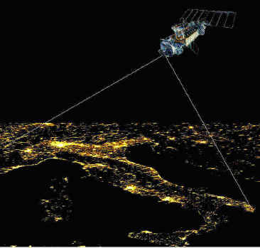
The night sky in the WorldSatellite monitoring of the artificial night sky brightness and the stellar visibility |
The interest for the protection of the night sky from light pollution is growing every day. A global scale periodic monitoring of the situation is necessary.
Nighttime images of the Earth at night have been obtained from the Defense Metereological Satellite Program (DMSP) of the US Air Force since early '70. The first global image was obtained by Woodruff Sullivan in late '80.
These images only showed the geographic distribution of the sources on the Earth surface because the satellite detectors were saturated by the strong flux emitted by them and no quantitative measurements were possible.
Since 1998 unsaturated data become available, allowing quantitative measurements of the upward light flux emitted by sources.
However satellite data don’t give any direct information on the effects of this light flux on the night sky due to light pollution propagation. The aim of our work is to study these effects.
We measure the upward light flux of sources on the Earth surface based on DMSP satellite data and then we compute the effects on the night sky modelling the light propagation in the atmosphere.
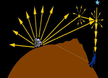 |
Depending
on the kind of map, we account for many details like the scattering of light by
molecules and aerosols, the extinction along light paths, the atmospheric
aerosol content, the Earth curvature, the altitude of each area, the mountain
screening, the observed sky direction, the natural sky brightness, the stellar
extinction, the eye capability.
In this site you can find information on our work, maps, scientific publications.
Istituto di Scienza e Tecnologia dell'Inquinamento Luminoso
Light Pollution Science and Technology Institute
|
Selected as a Hot Site in the 2001 Aug. 16th edition of USATODAY.com a free and highly popular news service on the World Wide Web. |
|
 |
Griffith Observatory Star Award for the week of 2001 Sept. 16 - 22 for excellence in promoting astronomy to the public through the World Wide Web. |
| Reviewed by |
Science, NetWatch, 293, 1407 (24 august 2001). |
| Reviewed by |
Physics Today, Web Watch, 54, 10 (October 2001) |