Istituto di Scienza e Tecnologia dell'Inquinamento Luminoso
Light Pollution Science and Technology Institute
The night sky in the WorldSatellite monitoring of the artificial night sky brightness and the stellar visibility |
The Night Sky in the Next Century
We are studying the effects of the increase of light pollution which is exponential almost everywhere with average yearly growth rates as large as 5%-10% measured both in US and Europe. Some preliminary projections have been tentatively made based on usual growth rates.
Growth of
light pollution in Italy 1971, 1998, 2025
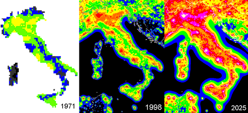
The figure
shows the growth of light pollution in Italy. At left the map of artificial sky
brightness in 1971 (Bertiau, Treanor, De Graeve 1973); at centre our map
calibrated to 1998; at right a possible scenario of the artificial sky
brightness in 2025. We compared Bertiau’s map with a map obtained with
satellite data using the same propagation law used by them (Treanor law), we
determined the average growth from 1971 to 1998 and then we rescaled our map of
1998 to 2025 assuming the same growth.
This figure is copyright but may be reproduced by the press in articles citing our research with the following credit/copyright statement:
Credit: P. Cinzano, F. Falchi, C. D. Elvidge. Copyright 2001 ISTIL, Thiene. Reproduced from ISTIL Report 2001.
Levels correspond to a fraction of a reference natural sky brightness (251 ucd/m^2):
|
map 1971 (Bertiau
et al.) |
Our
map 1998, 2025 |
||
|
<5% 6-15% |
black grey |
<11% |
black |
|
16-35% |
blue |
11-33% |
blue |
|
36-110% |
green |
33-100% |
green |
|
>1.1 |
yellow |
1-3 |
yellow |
|
|
|
3-9 |
orange |
|
|
|
9-27 |
red |
|
|
|
27-81 |
violet |
|
|
|
>81 |
hot white |
Yellow
indicates an artificial sky brightness equal to the natural (so the total is
double).